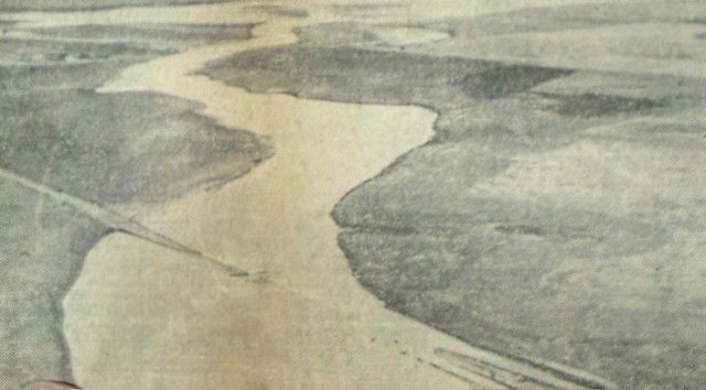
In the spring of 1951, Mother Nature played havoc with our little corner of the state. On Sunday, May 13, 7 inches of rain fell within an hour in an area six to seven miles northwest of Lakin bringing draws and creeks in the area to flood stage. Soon the highways were flooding, and the Highway 50 detour, seven miles north of town, was closed down. More rain on Monday raised the water in the flooding gullies even higher. The washout damage on highways continued north and east of town, but things were just getting started. That morning, a heavy rain also fell in eastern Colorado, and soon a record-high flood crest on the Arkansas was reported. Local police and highway officers kept watch throughout the night as the river continued to rise.
The crest reached Lakin about 6 a.m. Tuesday morning. As flood waters spread out over lowlands, travel on K-25 between Lakin and Ulysses was cut off, and Lakin was marooned from highway travel most of that day. The only way out was to Garden City by taking the Grange Hall Road nine miles north of town and then going east until arriving north of Deerfield. Rail and bus travel was at a standstill, and mail was delayed for days. Although the Arkansas was out of its banks all the way from Lakin to Lamar, neither Lakin nor Deerfield were in any danger of flooding from the river or the surface water from the north.
Rain-swollen streams caused wide-spread flooding in parts of Kansas, Oklahoma and Texas. Four miles east of Syracuse, 22-year-old Gene Lusk of Kendall fell off a railroad bridge while working with a Sante Fe crew repairing flood-damaged tracks. Lusk, wearing hip boots and a heavy raincoat, was thought to have struck his head as he fell into the Arkansas River. Fellow workers tried to rescue him, but the young man drowned.
The following Sunday, May 20, Lakin was struck by a flash flood, and streets became roaring rivers as the wall of water rushed through town in a matter of minutes. The water varied in depth from about five feet at the corner of Waterman and Buffalo to about five or six inches over most of the lawns in the high sections of town. The depth of water on Main Street ranged from about 20 inches to two feet near the depot and about six to eight inches on the higher levels.
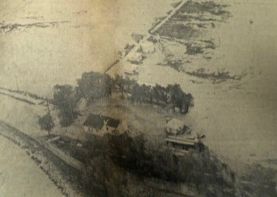
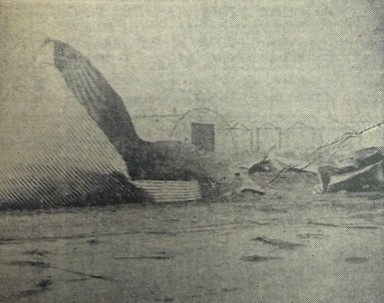
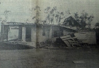
Hail, violent winds and two small tornadoes preceded the flood. One to the south of Lakin tore through a two or three-mile stretch and demolished buildings and trees in its path. Considerable damage was done to the farms of Wallace Roderick, William Schibbelhut, Davis Williams and Paul Bentrup. The other twister struck government storage bins two miles north of town, wrecking about five or six of them and strewing them for a half mile or more over a wheat field to the east.
Following a 40-minute heavy rain that dropped 2.5 to 5 inches in a small area northwest of Lakin, a wall of water formed across Sand Creek and was held back by the Amazon and Eastern irrigation ditches. US highway 50 also held back a considerable amount of water. When this spilled over the top of the ditches, it rushed down the highway in a solid wall of water about two feet deep. Water flowed across HWY 50 at the ditch bridges just west of town to the depth of the side railings, and several persons in automobiles raced into town ahead of the rushing water. The fire siren was sounded as a warning for all residents to prepare for the flood conditions, but there was little time to sandbag or even move valuables to higher ground.
Cars were unable to move east and west through the town, and several tractors were used to get people back and forth over the deepest areas. Men struggled through water as deep as their shoulders to reach homes and businesses. At the crossings where the current was the swiftest, chains of men formed to ford the rushing waters so that no one would be swept from their feet. Practically every home owner received damage to either their home or lawn from the muddy water, and many had as much as 18 inches of water coursing through their homes. Acid Engineers, Chemical Process Co. and Colorado Interstate Gas Co. had trucks and men available to help pump out basements.
Considerable damage was also done to vehicles and houses by hail ranging in size from golf balls to larger than hen eggs. The Santa Fe Railroad tracks east of town also washed out. Only moments before the lights went out and with back-up lighting provided by two candles and a cigarette lighter, Kyle Penelope Davis, daughter of Mr. and Mrs. Drexel Davis, was ushered into the world by Dr. Sabo and his staff at the Sabo Clinic on Lakin’s Main Street.
Just a few days later, another terrific hail storm slashed across the northern part of Kearny County smashing farm buildings, homes, vehicles and crops. The storm originated in Greeley County and spread over an area more than 100 miles long and 15 miles wide. All the windows on the north side of the Leo Michel home 17 miles north and six miles west of Lakin were smashed, and the house was stripped of its shingles. Just to the west and north of Lakin, every window facing west in Gordon Crone’s new home was broken. One hailstone bounced 21 feet through the living room and smashed out another window on the south side. Crone reported that even the buffalo grass in his pastures was beaten into the ground. Many more homes also felt the storm’s wrath. North of Deerfield, where the hail strip widened and mowed everything down in its path, hail battered the siding on Maurice Combs’s house making holes large enough to stick a quart paint can into.
Noah Hoyt, Lakin’s official government weather observer, recorded a total of 6.24 inches for the month of May 1951 with most of the moisture recorded over a 10-day period from May 12 to 22. Another 1.71 inches was recorded in the first six days of June. Some sections of north Kearny reported as much as 10 inches that May, and nearly $167,000 was sustained in flood damage that year. After being breached on several occasions and sustaining continual flood damage, the Great Eastern Ditch was abandoned after the 1951 flood.
SOURCES: History of Kearny County Vol. II and Archives of The Lakin Independent, Wichita Eagle and Parsons Sun.